Somewhere in the dregs of January, in the midst of a whirlwind romance, Harris and I started talking about bikepacking the Colorado Trail. The CT had been high on my list to bikepack for many years. But clocking in at nearly 550 miles, with roughly 75,000 feet of elevation gain, it always seemed daunting and the timing just never quite felt right.
I completed my first longer-than-an-overnight solo bikepacking trip on the Arizona Trail back in October, riding the course of the AZT 300. Tackling such a difficult and remote course by myself gave me the confidence to take something as massive as the CT on. I knew it had to be my next big trip and my decision was cemented when I met Harris.
We had both recently moved to Durango and were overwhelmed by all there was to explore. We’d go for quick fatbike rides on winter weekends and then pore over maps on the coffee table, dreaming of spring and summer and ground not covered by a blanket of white. A CT trip felt like the perfect way to get to know our backyard.
“Pick some dates and let’s do it,” I said in my get-shit-done tone of voice. We both blocked two weeks in mid-July off our calendars. We didn’t have a specific goal in mind but I definitely wanted to finish the course in a respectable amount of time at a touring pace. Ten days became our arbitrary goal, but we gave ourselves two full weeks if needed. The trip felt far away, but I knew it would sneak up on us quickly. The beginning of 2016 was crazy in a lot of ways. Weather, health problems, and general life-happening all conspired to keep me from spending much time on my bike.
We managed to squeeze in a few bikepacking overnights in May, including a trip on the Kokopelli Trail over Memorial Day Weekend. It was comforting that we were able to ride the 142 miles from Loma, CO to Moab, UT in 2 days.
If the beginning of 2016 didn’t present ideal conditions for preparing for the CT, June was an especially busy month. I barely pedaled my bike at all. If anything, I hoped, the lack of riding would make me fresh on the outset and I’d gain strength as the days multiplied.
The week before we were slated to leave on the CT we had to go to Indiana for a memorial service. Spending 40 hours in a car wasn’t exactly where I wanted to be right before our trip, but it made me crave the CT even more. I joked that pulling a 20 hour drive off in 24 hours, twice, must be mental fortitude training.
When we got back from Indiana, I still had to work a few more days before we left. Those days were frantic, making sure everything was done at work, while making final gear purchases and worrying over my trail food and pack job. By the time Sunday rolled around, our original departure date, I was definitely fighting off a sickness and my body felt wrung out. Harris was cool enough to agree to leave a day later so I could rest and finalize my pack job.
Sunday night we got everything packed and organized to throw in Harris’ car the next morning to make the 6 hour drive from Durango to the Waterton Canyon Trailhead outside of Denver. I slept fitfully, distracted by trying to will my body to recharge and ready itself for the trip.
Day 0.5 – Getting to Waterton Canyon TH
Monday, July 11th, 2016
Miles: 27.4 (Segments 1-2)
The alarm went off at 6am. We shot out of bed, made coffee, and jumped in the car. After months of imagining this day, it was finally here! We sang along to country songs on the radio and tried not to feel too nervous with anticipation.
I was voraciously eating sweet potato chips at 10am, somewhere around Poncha Springs, when I realized just how hungry I was. My planning had gone into the trail food in my bags, but I didn’t really think about what I would eat for breakfast or lunch the day we drove up to the trailhead. We were planning to ride some miles that afternoon so I would need to have something other than coffee in my belly.
Even though I hated to be I was feeling especially finicky about food. For the past month I had been following a strict anti-inflammatory and blood tonic diet, receiving regular acupuncture treatments, and taking regular doses of chinese herbs. I put a lot of thought into what I could bring with me on the trail that would support this diet but was still lightweight and packable. Kale chips, seaweed, goji berries, etc. I didn’t want to lose all the progress I had made with my health in the last month, but I also knew that doing something as strenuous as the CT was bound to fatigue my body and set me back a bit.
There was road construction all along Highway 285, and hordes of tourists everywhere we looked, but not much in terms of food options. We found a gas station that advertised breakfast burritos and felt like we were in luck. How bad could they be? We got the pre-prepared burritos back to the car and hungrily unwrapped the foil tops in sync. We both took big first bites. And then a second. And then exchanged concerned looks. The burritos were filled with some strange molten lava green chili cheese goop. The taste and texture were equally revolting but somehow kept us coming back for more. I ate all but the final bite and immediately felt like I had made a critical error before even reaching the trailhead. What would this do to my system? I was scared to find out. As my stomach worked through the breakfast burrito I felt a little bit better when I didn’t puke or have a bathroom emergency.
Around 2pm, after all the traffic, construction, and searching for food, we reached the Waterton Canyon TH. We would leave Harris’ car here and ride our bikes home to Durango, the whole trip theoretically feeling motivated to press on in order to reach home.
We got all our bags attached to our bikes and did a little test ride in the parking lot. My frame bag held extra water for cooking, food, a small stove, and cooking supplies. My seat bag held extra clothes, an emergency tarp, and rain gear. I had two bags attached to my handlebars packed with snacks. A bag strapped to the front of my top tube held tools and my phone. Nestled in the crook between my seat post and top tube was a bag that held my ID, a credit card, USB chargers, a headlamp, and miscellaneous items that wouldn’t fit elsewhere. The bag strapped to my handle bars held my sleeping bag and liner, first aid supplies, and toiletries. My sleeping pad was attached to this and I topped it off with another bag with more food. Easily accessible were my chapstick, water filter, and SPOT device. This was everything I would need for the next ten days. Note: Harris carried the tent we shared.
Everything seemed dialed in and ready to roll, aside from my nervous stomach, which was still gurgling from the lava content of the breakfast burrito.
It was hot and exposed in the parking lot and I was sweating buckets before we even started pedaling for the day. An older mountain biker rolled into the parking lot just as we were about to take off. “Ah, bikepackers!” he exclaimed. We told him we were just about to begin our journey and how excited/nervous we were. He looked at our bikes and gear skeptically and launched into a long and unsolicited account of his experience section riding parts of the trail over the years and how DIFFICULT and GNARLY and DANGEROUS it all was. We could barely get a word in edgewise and really just wanted to take off to experience it for ourselves.
I couldn’t help but think of how few people I interacted with on the AZT. It was already becoming apparent that we would see considerably more people on the CT. Finally we were able to make an exit from the one sided conversation and get on the trail. It felt like a hasty and unceremonious start as I was just trying to get away from the chatter.
We passed a group of school age kids hiking before we reached the big iconic brown and tan sign marking the beginning of the CT. We couldn’t pass up the photo op. Harris asked the kids if any of them knew how to take a photo with an iPhone. One kid got really excited and took a great photo of us. Their group leader asked if we were riding the whole trail. She told all the kids how brave we were for riding all the way to Durango. They waved as we set off on our journey.

We began pedaling the easy climb up Waterton Canyon on a gravel road along the river. We knew it would be about 7 miles of this so we settled in and enjoyed the scenery. Between the heavy traffic getting to the trailhead and all the people we encountered in the parking area I was ready to feel far from the crowds and immersed in the solitude of the trail. Within a few miles I was able to decompress and feel like the adventure was finally becoming real.

There were signs everywhere about how dogs weren’t allowed on the trail due to the bighorn sheep population. We saw several packs of bighorn sheep on and near the road. Even though the beginning of the trail is so close to Denver, I was impressed by how remote it immediately felt.
After the gravel road we began climbing more steeply on singletrack. Some of it was rideable, some of it made us dismount and hike our bikes. Since I hadn’t been on my bike much in the last month, I was trying to get my regular bike handling skills back while simultaneously getting used to the bike being loaded with weight. I felt a little clumsy, but reminded myself it was our first day and we really didn’t have much of a goal beyond finding a place to camp for the night. After we passed Bear Creek the trail turned to pretty much entirely hike-a-bike. We ran into several thru-hikers who had just started their hikes that morning. I noticed all the thru-hikers had the same sleeping pad as mine and the same water filter sticking out of their packs. It was like the thru-hiker uniform. Most of my gear choices have been informed by ultralight backpacking so it makes sense. We pressed our way up the loose climbs. Eventually the trail became much more rideable and we reached the top before descending down to the Platte River, ending segment one.

The afternoon was so hot we had already sucked down most of our water. I was only carrying two bottles on my fork and an emergency liter of water in my frame bag, but that was mostly reserved for cooking dinner since it was a pain to dig out. I was hoping to cross enough water for two bottles to be enough. Compared to the six liters I carried on the AZT, this was a huge change and allowed me to ride the CT without a backpack. We checked the guidebook and realized the Platte River would be our last reliable water for a long stretch so we filled up using our filters. The water was clean, clear, cool, and tasted amazing! Most of my bikepacking trips have been in the desert where the best water sources you could hope for were silty mud puddles. The brisk mountain streams and rivers of the CT were a welcome change.
We began segment two by climbing up away from the Platte River. The trail was well built but very loose. We rode what we could, but the loose sand and gravel made momentum difficult to gain and retain. We saw our first fellow mountain bikers on this section. They had big bulky panniers. It looked difficult, especially on this section with the periodic hike-a-bike. Evening was coming on but we decided to try to make it past Buffalo Creek so we could get water at the fire station before making camp for the night. The five miles leading up to the Buffalo Creek fire station were beautiful in the evening light. People call this the Top of the World, I guess because it’s the first taste on the CT of those amazing epic views. I tried to strike a balance between taking in my surroundings and paying attention to the trail in front of me, enjoying the rideable terrain. Later we heard there was a wildfire here just a week after we passed through, likely caused by lightning. Luckily they were able to contain it quickly.

We filled all of our water receptacles at the fire station spigot and drank a bunch extra. It’s always nice to encounter potable water and not have to worry about filtering it. The section from the Platte River to the fire station had been hot, dry, and exposed. I started to feel the cough that I had been fighting for days coming back in the dusty conditions.
We got a little ways past the fire station and made camp on a fire road at sunset just before the Little Scraggy TH, which would mark the conclusion of segment two. We had ridden about 27 miles in our half day, which was a great start considering how late we had left Waterton and all the hike-a-bike we had already encountered. The sunset was beautiful. We quickly set up our tent, got into our dry sleeping clothes, and made dinner up the road looking at mountains in the distance and trying to figure out which ranges they might be. The sun went down as we were making dinner, but we had our headlamps and the nearly full moon was bright. We could see Mars and a sky full of stars. After a hectic morning getting to the trailhead, it was a relief to be out here with just each other cooking our ramen, instant potatoes, and tuna under the giant night sky.

I drank my herbs, made an emergen-c to help keep whatever sickness was following me at bay, and had some after dinner tea. I felt relaxed, happy, and full. For the first time in weeks I had the opportunity to just sit still and take in my surroundings. We went back to the tent and put all our food in a separate bag. We tried to make a bear hang but all the trees were scraggly or dead so it was difficult. Eventually we got it “good enough” and slept lightly, hoping our food would be there in the morning. I woke up to a pronounced snuffling noise outside of our tent. I woke up Harris, scared by how close it sounded, and we listened until we heard the sound go away. I went outside to pee. When I got back into the tent, it was only about five minutes later that I heard the snuffling again.
Day 1.5 – Little Scraggy to Kenosha
Tuesday, July 12th, 2016
Miles: 47 (Segment 3, Lost Creek Wilderness Detour, half of segment 6)
We woke up holding hands at 6am and rushed out to check the bear hang. Our food was still there and whatever animal had been snuffling around in the night was long gone. We were able to get everything packed and were riding by about 7am. Leading up to the trip we were both a little worried we wouldn’t be able to get out of camp very early due to our natural inclination to sleep in. Our first morning on the trail was promising. My sore throat felt more pronounced but I tried to ignore it.
The country songs from the drive up were on repeat in my head. Our trail refrain quickly became “Huntin’ and Fishin’ and Lovin’ Everyday” by Luke Bryan. It was always stuck in my head. Especially early in the morning when we found it hard to get up and get moving. We would just goofily chant this song.
We started just about a mile from Little Scraggy TH and were treated to some really awesome trails in the Buffalo Creek area, a place popular with day riders. It was all rideable, mostly smooth, peppered with some rocky and technical areas. Even though route finding had been fairly breezy with frequent confidence markers and easy to follow intersections we encountered a bewildered thru-hiker in this section who was convinced he was lost. I was able to verify our location with the CT app on my phone to show him that we were on track. I downloaded this app at the last minute and barely had time to look at it before we left. It was extremely intuitive and ended up being an amazing resource throughout the entire trip. I was able to offline the maps of the CT and then use GPS even in airplane mode to tell me where we were in relation to different waypoints. Harris used the databook, but I pretty much strictly used the app. The biggest difference I found was that the databook gives a more visual representation of elevation gain and loss.
After we were riding for an hour or so we ran across some thru-hikers packing up for the morning. Harris immediately recognized one of them as someone he had known when he lived in Burlington, VT. It was such a funny small-world moment. They caught up briefly, took some selfies, and we wished them well and went on our way, promising to meet up whenever they made it to Durango.
The rest of segment 3 was enjoyable and rideable. We made it to the Forest Road 560 by mid-morning. On the way to Waterton the day before we had scoped out Highway 285 between Kenosha Pass and Bailey, assessing the traffic and shoulder. We were thinking instead of doing the Tarryall Wilderness Detour we would opt for the shorter (but more trafficked) highway detour that the Colorado Trail Race used to follow, allowing us to resupply in Bailey and cut some non-trail miles. The 20 mile stretch on 285 looked a little sketchy but doable. We resolved it was the better option.
By noon we were eating gas station cheeseburgers at the Conoco in Bailey. It was a bustling spot in town. We drank our fill of gatorade and I got some individually packaged cold medicine priced at a premium. We sat outside the gas station building up our nerve to ride up the pass in heavy traffic.
After less than 24 hours on the trail, I already felt filthy and weird being around so many people at the gas station. A lot of passersby seemed intrigued by us. One old man saw our bikes and said, “Are you guys doing that thing from Canada?” I assume he meant the Tour Divide. We said no, “just” the CT. He frowned and seemed disappointed. A younger guy just a few minutes later asked where we were riding from. When I said Denver on the CT he seemed super unimpressed. It was funny to feel like we were taking on such a major challenge and have people be so unimpressed. I think people unacquainted with the CT just have no idea how challenging it truly is.
It was time to start heading up the highway and get back to the trail. The highway climb started out pretty mellow and we had a shoulder on and off. Most traffic was respectful, but it was moving so fast that it was scary regardless. A few big trucks got within inches of us. As we got about five miles away from the pass the grade got steeper and the shoulder more scarce. There was one section where we got passed at close proximity by a semi and I fell off the road into a ditch. After this it was pedal pedal pedal to reach the top as quickly as possible. We were baking under the strong early afternoon sun.
We were relieved to get to the top of the pass at the Kenosha TH. I suddenly felt exhausted and like I had to take off my shoes or my feet would burst into flames. We ran into a big fluffy black trail dog hanging in the shade and sat with him for a while. His owner said he was lazy that day and she could barely get him to move. He was less lazy when beef jerky was involved.

After lounging a while fighting flies and mosquitoes we decided we should start riding if we were going to get beyond the Kenosha TH. We started picking our way up a rooty climb through through the aspens. My legs felt like they didn’t want to work. We walked it out for a while, got some water in a mosquito-y creek, and tried to keep moving even though we were both exhausted. We had Georgia Pass coming up. Since it was our first pass on trail we weren’t sure how wise it was to do it in the afternoon/evening. Neither of us were experienced with hiking or biking in the high country, so we thought it might be more wise to camp below the pass and get over it early in the morning. We kept moving but were actively looking for camp spots.
We got to Jefferson Creek around 5pm and decided to make camp. It was early but we liked the idea of splashing off in the cool creek and having plenty of water for cooking and washing up. The bugs near the creek were ruthless. I wanted to get into the creek without my clothes on but once we got down there we realized there were tons of other campers. So much for my dream of bathing. We found a group of bikepackers near to where we splashed the dirt and grime off our arms and legs. They had done the whole CT ten years prior fully supported and were out on a tenth anniversary ride self-supported. They had already been out for four days and still were feeling demoralized from the wilderness detour we had routed around. I felt kind of bad that we hadn’t done it, but since we weren’t racing there weren’t exactly rules so we went with our gut. Even though 285 was scary in its own way, it sounded much less soul-sucking than the detour these guys had endured. They said it was hot and exposed with a killer headwind and they got stopped in a construction zone.

The Jefferson Creek area was full of campers and we met several thru-hikers. One was super chatty with us and we learned his trail name was Nordictrack, he said he earned it because he was the “king of cardio”– we all laughed and shared trail stories. He said we needed to come up with trail names that made us feel powerful. I had no idea what that might be and the whole idea of trail names and thru-hiker culture had always seemed a little goofy to me. But I was trying to lighten up about it.
He complimented Harris’ pink accents on his bike. His grips, hubs, headset, bottom bracket, and pedals are all pink. I called it “flair” and we both immediately decided that should be Harris’ trail name. Flair it was.
I looked at the app before we went to sleep to get an idea of what was coming the next day. Users have the ability to add comments to different waypoints. I noticed someone had made comments about high bear activity at Jefferson Creek. Harris and I took turns reading a story out loud to each other from an e-book on my phone and I fell asleep easily despite the bear warnings.
Day 2.5 – Georgia Pass to Copper Mountain
Wednesday, July 13th, 2016
Miles: 39 (Segments 6-7)
We woke up early and refreshed since we had set up camp so early. There was a pit toilet nearby and I was relieved to not have to deal with the regular morning routine of digging a hole. It’s funny when you begin thinking pit toilets are the marker of luxury.
We were six miles from the top of Georgia Pass and had no idea how long it might take. We crossed the creek, leaving sleepy campers behind. We began pedaling in earnest and almost immediately had to hike our bikes over a rooty and rocky steep trail. After only a short bit of this the trail became instantly more rideable. Still rooty technical climbing, but doable! I led the charge and Harris followed behind. Every time we stopped to regroup he acted so impressed with my riding. It was flattering. I’m not used to letting someone ride behind me, and I usually ride by myself, so it felt nice. At one point he told me I was a “babe rainbow” and I remembered this was one of the first compliments he gave me way back in November when we first met. It made me giggle back then but in the context of the trail I immediately realized he had spoken my trail name. We laughed and decided we were Flair and Babe Rainbow. I liked Babe Rainbow because it felt powerful and sparkly at the same time.

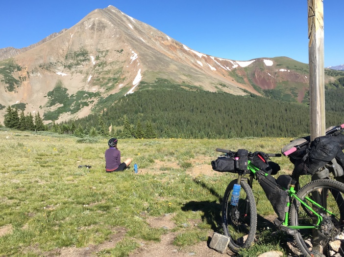
We kept riding up to the pass, eventually getting above treeline, and topping out at 11,598. When we got to the top it was still early. The morning light bathed the nearby peaks in golden light. We sat quietly enjoying the view and a snack when suddenly Harris got really excited and started pointing at a group of four mountain goats that were slowly ambling towards us. We made eye contact and they started walking the other way. Every time we looked away from them they would start approaching us again.

We began descending from the summit, dodging lots of thru-hikers. The descent off of Georgia Pass was ripping. It was fast, rooty, and fun! The trails to Breckenridge were some of the best riding we had experienced so far on the CT.
We ran into a solo bikepacker somewhere before Breckenridge and stopped to chat with him. I was excited to see so many bikepackers and loved seeing the different ways everyone packed their gear. This guy was from Hawaii. He had a chiseled physique and a very dialed in setup. He immediately started complaining about how the CT was nothing like he expected. He had run out of water numerous times, succumb to cramping and dehydration, and wrecked a few times. He complained about the climb up to Georgia Pass and said he was going to stop in Breckenridge and decide whether or not to proceed. I tried to empathize, remembering struggling on the AZT by myself and feeling relieved when I was able to commiserate with another trail user. But I was surprised that he wasn’t expecting the CT to be “this” difficult. I’ve always understood the CT to be insanely difficult, so I guess I was mentally prepared for it to be even more difficult than it was. He rode off ahead of us and we passed him a few miles down the trail as we were cranking up a steep grade. I tried to say something encouraging like “see you down the trail!” but he just grumbled and crouched in the shade of a low tree. We didn’t see him again.
I had ridden parts of this Breckenridge section last summer and remembered a crazy zig- zag of a descent at the end with barely rideable switchbacks. Once we got there I knew we were pretty much in town. We had enough food to get us to Leadville so even though we could detour off the route to resupply in Breckenridge or Frisco we opted not to. I like a quick resupply and both of these towns seemed like they might distract us from our mission.
Even though Harris was pretty hungry and had a hot meal on the brain, I got my way and we sat at the Goldhill TH to eat our meager trail snacks before pressing on to what we had heard was one of the toughest hike-a-bikes we’d encounter on the trail. Harris was pretty sad there was no taco truck or pizza cart at the trailhead, but we managed to stuff ourselves with what we had packed and didn’t have to go into either town.
It was 3pm by the time we decided to start heading up from Goldhill TH. It felt like it went against everything I knew about climbing up above treeline to do it in the middle of the afternoon/evening, but the skies were perfectly clear and there wasn’t anything in the forecast. It’s tough on the bike to plan your days around trying to get over high points early since you also are trying to cover more ground than one summit a day. We started heading up, warily climbing, waiting for the punch in the face we knew was coming. It was only 12 miles to Copper Mountain, which meant the summit was about 8 miles ahead.
We rode as much as we could knowing the rideable portions wouldn’t last long. This was the section that the mountain biker in the parking lot at Waterton had been especially emphatic about. He encouraged us to ride the bike path around it.

Harris had a friend, Chase, from Vermont, who had started bikepacking the CT three days before we left. Chase had texted to tell us he routed around this section. We knew we were in for something unforgettable. The final 4-5 miles to the summit was entirely hike-a-bike. And not just the kind of hike-a-bike where you’re pushing your bike alongside you or gingerly in front of you. No, the Tenmile Range was the kind of strategic hike-a-bike that involves lifting your bike above you and using it to hoist yourself up or pushing it a few steps in front of you, grabbing the brake, and using it as an anchor. Repeat this hundreds of times and that’s how I got up and over the Tenmile Range.

The summit was elusive and I cursed the app for constantly reminding me how slow we were moving and how little ground we had covered. I knew if we kept moving we would get over it by dark. Step step, push, brake, step step, push. Despite the intensity of this section, it was beautiful in every direction. We could see Breckenridge and the zig-zag switchbacks we had descended hours before. We had an uninterrupted view of mountains on every side of us. Marmots played in scree fields and the wind blew at high speeds. We didn’t see any other thru-hikers or bikers on this section until we passed the summit and saw an ultralight thru-hiker crushing it. He advised us to stop and resupply in Copper at the resort store. I had no real plans other than making it off this mountain before dark and alive.


Eventually we started a harrowing and fast descent into Copper. It’s amazing how fast you can descend something that took literally hours to ascend. Gravity is a force. We got to the bikepath in Copper and I didn’t know what I wanted to do. I just wanted to cry. The Tenmile Range was stressful. I had been so focused on getting up and over it that I didn’t have any time to relax. Now I just felt shaken from hours of being tense, mentally and physically. I knew I needed to eat and we needed to find a place to sleep. We spotted a campsite near the river that looked somewhat legitimate and threw our tent down.
It was about 7:30 and things in Copper looked like they were closing up. It was the last place on earth I wanted to be. Some resort area where everything looked the same. We found a restaurant at the golf course and even though they were about to close up they were kind enough to serve us. Cheeseburgers and fries! Even though I was starving I could barely finish my food. The waiter told us stories about his days of road touring and gave us a nice discount. I guess Copper wasn’t so bad after all.
My body temperature suddenly dropped after dinner. I needed to get in my sleeping bag and warm up. Harris went to the convenient store to get water for us while I went back to the tent. He came back to report they were closed but would reopen at 7AM. We crashed into our sleeping bags with minuscule ambition. We set an alarm but didn’t talk about goals for the next day or when we wanted to get out of camp. We didn’t even hang our food, just threw it in an odor proof bag and hoped for the best.
Day 3.5 – Copper Mountain to Mount Massive TH
Thursday, July 14th, 2016
Miles: 49 (Segment 8 & Holy Cross/Mount Massive Wilderness detour)
This was the hardest morning we had on the trail. It was freezing when we woke up and we had laid down in a hurry the night before, leaving our bags and pack jobs disheveled. We didn’t have any water and even though we were right next to a river we didn’t have the wherewithal to climb down to the banks to filter water. I had woken up repeatedly in the night to a coughing fit, the dreadful sickness I was fighting was just hanging on. We knew the convenient store, which was right next to a donut shop, would open at 7am. We crawled out of our sleeping bags into the cold morning and hastily packed our bags. We got to the donut shop shortly after they opened. I was excited for real coffee and lots of calories. Unfortunately there was a major internet outage and no one’s credit card machines were working. Luckily Harris had cash and let me get whatever I wanted. A large coffee, ham and cheese croissant, and a raspberry oat bar.
I sat sullenly staring out the window, not very excited about the day ahead, feeling like all I wanted to do was sit in Copper and sip coffee. I made a deal with Harris that as soon as the sun lit up the parking lot I would consider leaving, but I was too cold and unmotivated to begin our day in the shadows. The sun seemed to take forever to come over the mountains. After filling up on coffee, getting some cold medicine and cough drops, we mustered the energy to get moving. This was the latest start we got on the trip, about 9am.
Once we started moving my body felt much better about the prospect of riding all day. I have a really hard time getting going when I wake up cold and it’s dark. The sun was a welcome sight that morning and I was overjoyed when it filled the sky.
We knew we had lots of climbing to reach Searle Pass, Elk Ridge, and Kokomo Pass. I readied myself mentally for another tough day filled with hike-a-bike. The trail surprised us by being much more rideable from Copper to Searle. We were treated to some really nice high alpine meadow riding all the way to Kokomo Pass. Again, we had clear skies and amazing weather. This was one of my favorite sections of trail. It was positively gorgeous and it felt so special to be there on a bike.


When we got just below Elk Ridge there were several switchbacks. We saw a bird in between the switchbacks and didn’t think much of it until it charged us and Harris fell down with his bike on top of him. This grouse was extremely overprotective of its chicks! It kept puffing itself up and charging us. This is the only time in my life I cut a switch back! After we were out of the grouse’s charging line we ran up and over the ridge laughing and screaming. I joked with Harris about what we would do if we saw a mountain lion since we both got so freaked out by the grouse. We laughed and changed the subject.

The descent from Kokomo Pass to Camp Hale was amazing! Fast, chunky, and sorta sketchy… My favorite! In my head I thought we would bomb down off the mountain and immediately be in Leadville. I guess I wasn’t paying close enough attention to the map because right after we descended we had to start climbing again to Tennessee Pass. I was hungry but holding out for a warm meal in Leadville. As we started climbing and I realized we had a ways to go before we would reach Leadville I dejectedly sat down on the side of the trail and ate a Pro Bar.
After this first demoralizing section the trail got a little better and I settled in, thinking how silly it was to put off eating when I had plenty of food in my bags. I have a hard time feeling hungry when I’m on my bike. I rarely eat much on day rides, but I knew this was different. I usually don’t realize how faded a calorie deficit has made me until I consume some calories and feel them kick in.

The riding got really good the closer we got to the wilderness detour and we were treated to some wonderful singletrack. We met some mountain bikers out for a day ride who were section riding a bunch of the CT. They were impressed by our progress which made us feel a little better after a rough start to the day.
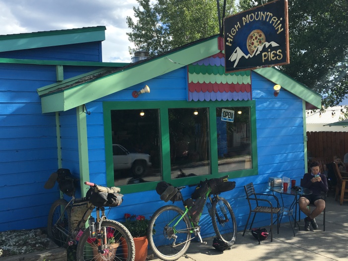
Eventually we made it to the wilderness detour and took the highway into Leadville. It was around 5pm and we were more than ready for dinner. We skipped the grocery store, still feeling like we had enough food to last us to Buena Vista, and found an awesome pizza place called Mile High Pies. We drank pitcher after pitcher of water and I took a quick paper towel bath. I felt really at home in Leadville even though I was disgusting, sweaty, and tired. The people of Leadville made us feel welcome. Lots of cyclists passing by the pizza place talked to us about wanting to ride the CT or race the CTR but no one we had run into had actually done it. They said they knew when the CTR was happening because the Subway parking lot was always overrun with loaded bikes that looked like ours.
Our plan was to finish dinner and then finish the wilderness detour before setting up camp for the night. We rode away from town with full bellies and hearts, glad to have turned our day around.
We made it near the Mount Massive TH where there was lots of dispersed camping along the river in pine forests. We picked a spot and had enough light to make tea and enjoy camp before dark. Somewhere between getting in and out of the tent we broke the zipper on the rainfly of Harris’ tent. So far skies had been clear and everything had been dry but we knew stormy weather was imminent. We tried not to worry too much and crawled into our sleeping bags, falling asleep fast.
Day 4.5 – Mt. Elbert to Chalk Creek
Friday, July 15th, 2016
Miles: 65 (Segment 11, Collegiate Peaks Wilderness detour, segment 13)
We woke up early and hit the trail by about 7am. The trail was overrun with all kinds of day hikers going up Mt. Elbert. It was awkward because it was a tough climb and we kept getting passed by the hikers and vice versa depending on the grade. After about a mile of this yo-yo, we got to a trail junction where the CT diverged from the Mt. Elbert trail. Once again we had the trail to ourselves and we were descending nice and gradually. It was a beautiful morning out on the trail. When we neared the Twin Lakes area we were treated to some amazing fast and flowy High Sierra style riding. Suddenly we felt like we were in Northern California.

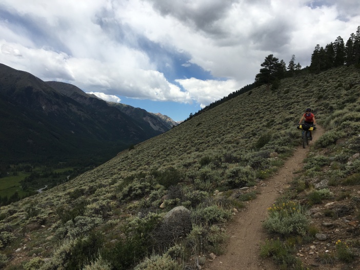
We were enjoying this section so much that it’s the first place we almost got lost. This is where the trail diverges into Collegiate East and Collegiate West. We were to follow the Eastern route because of the wilderness detours to come, but we missed the sign where the Eastern route climbed steeply away from the Western part. Luckily there was another trail intersection less than a mile up that prompted me to pull out my phone and check the app. We only had to backtrack about a mile and then began a very steep persistent climb away from the lakes. Eventually we dropped down to a gravel road near a reservoir where we would begin a wilderness detour to Buena Vista. The descent to this road was filled with sagebrush and other high desert vegetation that we hadn’t seen much on the CT. Being a desert girl at heart I really loved this section.
We rode past the reservoir and then onto the highway for several miles. The wilderness detour had us take a side road off the highway that paralleled the Arkansas River the rest of the way into Buena Vista. It was a gorgeous afternoon with the sun glinting off the water, watching rafters and picnickers, repeating our promises to ourselves to spend the rest of the summer after the CT sitting in a tube in the Animas River in Durango. There were natural tunnels along the dirt road and lots of big red rocks. I suddenly felt like we were in a very different ecosystem than we had been in the past few days.
When we started our trip we had thought we might stay in a hotel in Buena Vista to break up the backcountry sections and give ourselves the chance to relax. We got to Buena Vista early in the afternoon and knew there was no way we wanted to stop in the middle of the day so we headed straight to the bike shop for chain lube and the grocery store to stock up our bags with food. When we rolled up to the grocery store we saw three other bikepackers at the outdoor picnic table getting their provisions sorted out. We chatted with them a minute, commiserating, sharing stories and instant potato recipes, and found out they were on day 8 of their trek, hoping to complete it in 20 days. Of all the bikepackers we had met I felt like our pace was the most blistering, but 10 days felt like a reasonable touring pace to me.
We got a message from Chase telling us his friend had dropped out and he was going on alone. He sounded lonely and hopeful that we would catch up to him even though he had a 3 day lead on us and had skipped around a bit.
To get back to the CT from the wilderness detour through Buena Vista we would have to ride up Cottonwood Pass. We had filled up on food at the grocery store. Sandwiches, hard boiled eggs, fresh fruit, juice. My stomach was full to bursting. As soon as we hit the false flat straightaway leading to Cottonwood Pass we got pummeled with headwind and I thought I might seriously lose my lunch. I also knew I was close to starting my period as I was experiencing telltale abdominal cramping. I tried to ignore that and would deal with it when I was actually bleeding. I was hoping my body would just skip it this month since the CT was so taxing, but no such luck.
We started to climb more steeply after passing a hot springs where I had remembered going the first time I visited Colorado when I was ten years old. A guy in a little black car passed us slowly and cautiously. He stopped a little ways up the road in a pull out and yelled at us “I AM GIVING YOU ALL OF MY ENCOURAGEMENT!” while giving us an enthusiastic thumb’s up.
Finally we reached the top of the paved climb and rejoined the CT where the Cottonwood River flowed. It was the heat of the afternoon and after 4 days in the same shorts I was feeling pretty ripe. We gave ourselves a minute to take our clothes off and dip in the river. It was glorious, clean and cold! Shortly after we finished our river bath we saw a trail construction crew emerge from the woods. One of the guys worked for the Colorado Trail Foundation and had an IMBA sticker on his hat. We chatted with him for a while about the projects they’re working on to improve sections of the CT so they are more sustainable (usually means more bikeable). He was super cool and we made sure to thank him profusely for everything he does.
Shortly after we left Cottonwood Creek the trail took a turn for the unrideable. It was a chunky, loose, sufferfest of hike-a-bike for 6-8 miles and there was literally shit all over the trail. We gritted through it in the heat of the day. After what felt like hours we made it to a fast and fun jeep road descent down to Mount Princeton Hot Springs. The resort was in full swing and we toyed with the idea of staying there for the night.
I went into the lobby to find out how much a room would cost but turned around before talking to anyone because it was just too fancy. There was no way I would feel comfortable there. We did eat some overpriced sandwiches and potato salad from the resort store and then headed toward Chalk Creek. We had read some warnings on the app about the vicious mosquitoes at Chalk Creek. Sure enough, as we were setting up camp we were swarmed by the most insane clouds of mosquitoes I have ever encountered in my life. Needless to say we zippered down in the tent as quick as we could. We were lucky to have eaten at Mt. Princeton so we didn’t have to contend with the mosquitoes while we cooked. I slept amazingly. I’m not sure why, but it was a welcome change from the not so great sleeps I had been getting so far on the trip. On top of that, my sickness was abating and I was beginning to feel a lot stronger.
Day 5.5 – Chalk Creek to middle of nowhere
Saturday, July 16th, 2016
Miles: 44 (Segments 14, 15, & 16)
I slept like a rock and woke up not really sure where I was. Luckily the mosquitoes gave us a reprieve for the morning. Our spirits were high as we set out from Chalk Creek, but immediately we were hiking our bikes up steep rocky terrain and the heat felt intense even though it was still early in the morning. We finally found our way to the Mt. Shavano TH but were in for more rocky chunky unrideable terrain. Finally we descended down to Highway 50, took a lunch break, and chatted with some thru-hikers. An older couple came down the trail. The guy asked if he could share a “secret” of backcountry experience with us. We were hoping he had some snacks to share. He reached in his backpack and pulled out his jacket, narrating the whole time, “when you get done with 6 days in the backcountry, you reach into your pack, pull out your jacket, reach into the pocket…” he paused for dramatic effect… “and pull out your keys to unlock your Mercedes.” The nearby gold Mercedes SUV chirped. Not quite the useful secret I had been hoping for, but it was funny nonetheless. I couldn’t help but daydream about what it would feel like to finish the CT and arrive home in Durango. But it was way too soon to be thinking about that.
Sufficiently refueled and rested, we headed up a gravel road that would take us to Fooses Creek Trail and eventually Marshall Pass. We had no idea what to expect, but knew we were in for some climbing. We climbed up the dirt road, getting passed by vehicles full of day mountain bikers who had shuttled the ride (in the other direction). A huge pickup truck full of mountain bikes screamed down the hill at us without even tapping their brakes on a narrow gravel section. I waved my hands like “hello?!” and the guy yelled out the window, “What? You think you’re stronger than a pick-up truck?!” Um, no, but I would expect fellow cyclists to be respectful enough to yield to a rider tackling a tough climb, especially when your vehicle presumably has brakes. Luckily this was really the only asshole we encountered our entire trip so I let it go.
After 3 miles on the gravel road we got back onto singletrack and started picking our way up Fooses Creek Trail. The climb up started mellow so we wondered when the grade might pick up. It stayed rideable up until we popped out of treeline and we would ascend 668 feet in half a mile, the steepest grade on the entire CT. We knew we were in for some hike-a-bike, and as we got higher up the grade got seriously insane and the loose gravel made climbing sketchy. I employed my old brake-step-step hike-a-bike technique, but it was still tough. I kept thinking I might topple over backwards with my bike.
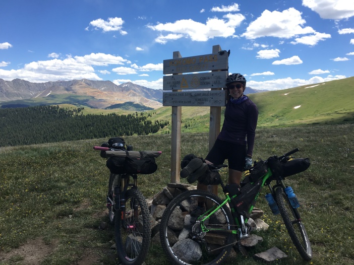
We saw some people up at the summit, and they looked naked, but they just sat there looking down at us. As we got closer the woman jumped up and threw on her shirt. It was funny that she seemed so startled since we were literally crawling up the side of the mountain for a really long time and she had to have seen us. I apologized for interrupting their sunbathing session and told them they didn’t have to get dressed on account of us. She laughed and said she didn’t want us to tell our friends about the flat-chested old woman we saw at the top of Fooses Creek. She was neither. They took our picture and asked us lots of questions about the CT. I remember thinking how clean and nice they smelled. It was funny to see people out on day rides who had probably showered that morning. They insisted on taking our picture since this was where the CT joined the Continental Divide Trail.

We rode up even higher from here, the trail went gently up and down through a high alpine section, then bombed down to Marshall Pass Road on jeep roads. We filled up on water, had snacks, and left about 6:30pm, hoping to make it about 12 more miles before making camp.

We rode through a section of jeep roads as evening light was painting nearby peaks amazing colors and the moon rose high above. The climbs were steep and we eventually got to a section where the roads were badly rutted and the terrain started to get much chunkier.


We got into a chunky rocky section that was difficult to ride. I think it was hard to hike, too, judging by how many hikers we saw who seemed to have just given up and crashed for the night right on the side of the trail. The woods were quiet and creepy. We were trying to make it to the next water source but eventually we gave up and set up camp since it was quickly getting dark. We had only made it 10 more miles from Marshall Pass Road. We had ridden (and hiked our bikes) for 14 hours that day and only made it a total of 44 miles. We barely took any breaks. This course really made us rethink our idea of how many miles we could ride in a day. Since we had gotten so few miles in this day and there were storms in the forecast we hatched a plan to ride the La Garita wilderness detour into the night. We wanted to get it out of the way and get to the high point early the next day before the worst of the storm forecast set in.
Day 6.5 & 7.5 – Middle of nowhere to just beyond high point
Sunday and Monday, July 17th & 18th, 2016
Miles: 112 (Segments 16, 17, 18, La Garita detour, and segment 22)
We slept in since the evening before had been somewhat stressful and we were actually sleeping really well in the quiet creepy woods. We got going around 9am and within a couple miles reached the creek we had been hoping to make it to the night before. There were several thru-hikers and some fellow bikepackers filling up their water. Two of the bikepackers had been out for ten days already and the other guy had been out twelve. They seemed fairly beat down by the preceding section, just like we were. We chatted a while and awkwardly pressed on at the same time as them. They rode our tails for a while, but we stopped seeing them once we climbed up into Sargeant’s Mesa.
We had heard of this section; that it was relentless, chunky, and fairly unrideable. A lot of the climbs were pretty tough just because they were so loose but the descents on this section were a ton of fun! I knew we would be on this section for a while and it was going to feel fairly monotonous so I tried to get in the zone where I can enjoy and endure bullshit, finding something zen in it. I was focused on getting through this section and moving on. The difficulty of the sections around Breckenridge were helped by how stunningly beautiful and special it felt to be on those trails. This section was made more insufferable by the fact that it really wasn’t that scenic and there wasn’t much to focus on. For that reason it took me back to my Midwest trail running days and I tried just zoning out.

A few miles into this section Harris began experiencing trouble with his cranks. They were loose and he was trying to tighten them with a special tool he brought that would have been much more effective with a wrench, but he didn’t have a wrench. We stood at a trail junction snacking and messing with the cranks when a group of moto guys rolled up. They turned off their engines to chat with us. They lent Harris a wrench and asked us all kinds of questions about what we were carrying, how much it weighed, and how many days we were out. They were also mountain bikers and were contemplating a similar trip. They offered us food and water, which I quickly refused, and then felt stupid. Sometimes I’m too proud to accept people’s kindness. Later near Silverton when we got low on snacks I would regret my pride. The mosquitoes and flies were relentless so we parted ways and kept plugging away at the chunky rock sections.

I was riding in front, fairly zoned out, when eventually I realized I hadn’t seen Harris for a while. I was at the top of a really brutal hike-a-bike section. I stopped, had a snack and drank some water, but I still didn’t see him. I felt like something must be wrong. I couldn’t decide if I should turn around on my bike and look for him or just look for him on foot. I remembered talking to him fairly recently so I decided to just jog down the trail without my bike to look for him. I went a quarter of a mile and didn’t see him. I was starting to feel a little loopy and was worried he had wrecked on the rocky terrain. I was yelling his name but got no response. I ran down the trail, terrified that something had happened to him. I eventually found him somewhere between half a mile to a mile down the trail — but it felt like an eternity before I found him! He had shredded a tire and had tried to call out for me but I guess I was too in the zone and hadn’t heard him. He was almost done fixing it, but was concurrently hot, tired, and frustrated. I tried to cheer him up the rest of the way through Sargent’s Mesa but it was pretty brutal and he was feeling frustrated by his bike. Even after tightening the cranks with his wrench they were loose and he worried they would just strip out.
Hours later we emerged from Sargents Mesa! We ended up on a short highway section and then rejoined singletrack right as the sky looked like it was going to open up and start pouring on us. We chatted with some thru-hikers who were about to have a “town day” in Gunnison and were waiting for their ride. They asked us if we knew a guy named Chase, Harris’ friend from VT, and said he was only about a day ahead of us now and was apparently telling all the thru-hikers to watch out for a “badass bikepacking couple” — we hadn’t had a reliable cell signal since Buena Vista so we had no idea where he might be, but we hoped to catch him since he was riding by himself now.
Harris took a minute to fix his cranks for good and I took the opportunity to load up on snacks and dig out my rain gear. The sky looked pretty cranky. I put my rain jacket and pants on, not interested in getting soaked.
We rode a short section of singletrack and old jeep roads through the Gunnison National Forest. It was only lightly raining on us and I started to overheat from my rain gear. At the same time I started to get really bad period cramps and felt like my legs were on fire. We stopped briefly and I tried to drink as much water as I could stomach. I kept thinking I really needed to hydrate and eat if we were going to ride through the night. Regardless of my cramps, this section of trail was extremely enjoyable after the pain of segments 16 and 17. It was gradual, less technical, and went through the gorgeous Gunnison National Forest.
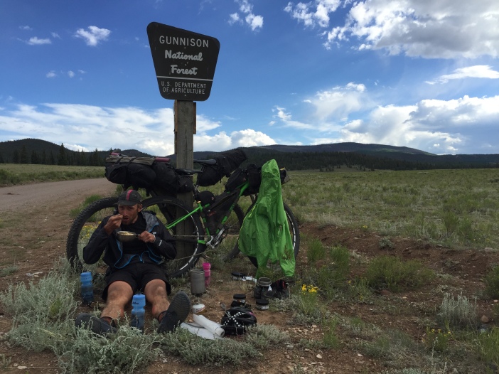
We got to the La Garita Wilderness detour around 6pm and decided to stop and make a hot meal since most of our easy snacks were depleted. We still had plenty of ramen and potato flakes. We feasted on the side of the road and made some instant coffee, enjoying the evening light.

We rode by a reservoir and filled all our water up, some of it we opted to filter later since the bugs were so bad down by the water. We got on our bikes and were feeling good. We had plenty of water, food in our bellies, and we were optimistic about riding these gravel roads into the night. Finally something rideable! We were happy to be spinning our legs. Just as we were letting this positivity sink in Harris took a gravel corner really hot and slid out, wrecking pretty bad and busting the buckle on his shoe. We took a minute to regroup and clean his cuts. We tried to stay positive and get stoked on night riding, but just as the darkness was starting to settle in we pulled out our powerful headlamps only to discover mine wouldn’t turn on. Luckily Harris’ light was bright enough for the both of us so we decided to keep going into the night, especially since the moon was nearly full. We settled into the gentle gravel climb and night enveloped us. We saw a couple of animals playing in the road and thought it must be a couple dogs. When we got closer we discovered it was two foxes prancing down the road. They ran into a fox hole when we got close.

We felt good all the way up Los Pinos Pass, the first climb on the wilderness detour, but knew there was another one coming after a descent to a river. We alternated between wide open meadows and more forested areas. I was paranoid about mountain lions, but we didn’t see or hear much. The night was still and it appeared to be just us. After our descent I was freezing. I had put on nearly all my clothes and still couldn’t stop shivering. My feet were numb so I even put on my rain covers hoping to trap some heat. I couldn’t ride my bike because the wind was too cold and I couldn’t stop shivering so Harris walked with me for a while. I wasn’t eating or drinking anything because it just felt too cumbersome in the dark.
What we could see of the creek and the cliffs adjacent to the road was beautiful in the faint moonlight. Finally after about a mile of walking I warmed up and we started to ride again. The climb was pretty mellow but sustained. A huge herd of elk crossed the road in front of us, mewing and barking as they hopped a fence. I had never heard elk make those kind of noises. At one point when Harris was scanning the sides of the road with his headlamp we saw an endless sea of eyes. Sheep! A whole field of them. They bleated at us softly as we passed.
Harris was starting to get tired and having a hard time staying on his bike. By this point it was about 2am and we had been riding all day and night since 9am without stopping much. He started talking about Les Miserables because he had one of the songs stuck in his head. I’ve never read the book or seen the movie so I asked him to give me the play by play of the plot. He spent the better part of the next hour giving me the full plot summary. I loved seeing his memory at work and hearing the parts that stuck with him. Even though I read a ton I have terrible retention for plot lines. I had so much fun listening to him I asked him to do another one after this. He went with Lord of the Rings because the setting and our experience was making us feel like we were on some sort of epic quest. This took about another hour and before we knew it we were at the top of the climb and about to hook up with Highway 149.
We had wanted to get to the point where we rejoin the trail before laying down for a couple hours but Harris was literally falling asleep on his bike and I was feeling squeamish about riding a mountain highway without a shoulder at 4am without rear lights. There was an outhouse at the top of the climb before the highway. We decided to throw our bikes inside the stall and sleep right outside under the awning in our sleeping bags. We wouldn’t have to bear-proof our food and we’d be pretty much ready to go first thing in the morning. We got our sleeping bags out and laid on the hard concrete. I didn’t feel too tired but once my body hit the ground I was out. I remember waking up drooling and checking the clock to find only an hour had passed. Harris was having a hard time sleeping and told me enviously that I had been snoring. 6am came quickly and I went into the bathroom to situate my things and figure out what I should still wear on the chilly climb up to the trail and what I could pack away. I came out of the outhouse and found Harris had fallen back asleep. I felt bad waking him up but we really needed to get moving. He gathered his things quickly and we jumped on the highway.
It was only about 5 miles up the highway until we rejoined the trail at segment 22, Spring Creek Pass. I was feeling motivated and climbed quickly up the highway. An entire family of marmots ran across the road in front of me. I waited for Harris at the trailhead and then we began climbing up a jeep road together. We stopped at the first water we found and made some hot breakfast. We didn’t have much food besides mashed potatoes and ramen left so that’s what we had for breakfast. We tried to gauge the clouds that were already building at 8am. I ate a few bites of food and instantly felt nauseous. I ran behind a rock to go to the bathroom and then laid down in the grass waiting for my nausea to pass. Eventually it did but I couldn’t stomach any more food as much as I knew I needed the calories after a full night of riding and barely eating anything.

We rode on toward the high point. The riding was good and the views were downright breathtaking as we crossed Jarosa Mesa and began to make our way towards Coney Summit and the high point of the CT. From the elevation profile in the guidebook we could tell that we had a couple of high points before we hit the high point. We were about 4 miles away from the high point but we knew that could take much longer than anticipated. Dark clouds were building ominously and all the hikers we saw were pulled off the trail either setting up camp for the night early or taking cover in trees before the exposed section.
We kept going and didn’t see anyone on the trail for a while. We saw a woman sitting on top of a rock eating an apple looking relaxed. Cool, I thought, she looks pretty experienced. Before the CT, I had zero experience with being in the mountains during storms so I didn’t know at what point the call should be made to either hunker down or turn around to get below treeline. I asked her what she thought, indicating how naive I was to this weather-in-the-mountains thing. She intensely told us that no one could make that call for anyone else and that you’re on your own in the mountains. Instead of making me feel better it made me feel more uncertain and we were quickly reaching the point where it would be difficult to get below treeline in either direction.
Operating on little sleep, Harris was starting to freak out a little bit. There were dark clouds looming over one of the first high points. He hesitated, telling me he thought it looked bad. I asked him what he wanted to do but we were both feeling pretty indecisive. We took what little shelter we could and waited for the darkest clouds to pass. We were laying under my emergency tarp just holding on to one another, too cold and tired to make any sort of decision. It was nice to take a break. The dark clouds passed and were followed by more dark clouds. I was beginning to feel like we might be stuck up here all night if we kept waiting like this. I asked if he would be game to try this first summit and then see what it looked like and assess from there. I hated to push him beyond his comfort zone, but I really felt like we needed to keep moving to get back to treeline before the storms started.
Hesitantly he climbed the first one with me. There were more dark clouds hanging over the next high point we had to get across. Harris asked if we could take what minimal shelter we could find again and take a breather. I acquiesced even though I really just wanted to quit prolonging the high point. I had to admit it was beautiful to take a break and sit there, taking in the views of the San Juans. My stomach was growling and I remembered the food I was too nauseous to eat earlier. I wolfed it down and immediately felt my energy level rise.
One more high point and then the high point. Then we would descend quickly and hopefully to treeline before any storms started. I convinced Harris to come out from under the tarp and keep moving. The last climb before the high point was craggy and steep. We crawled our way up. At the top there were more clouds, but we kept moving. The high point of the CT was 13, 271 and actually fairly mellow. We were able to pedal to it and stopped to quickly take pictures before getting out of the wind and the weather as fast as we could. We bombed down jeep roads and eventually got down to an elevation where we felt safer and could retreat into trees if needed.

Even though we had passed the highest point on the CT, we were still going to be at higher elevations for the next 17 miles or so on segment 23 from Carson Saddle to Stony Pass. This section was supposed to be a highlight of the CT but mostly above treeline. We weren’t sure what to do as storm clouds continued to build overhead and our combined fatigue got the better of us. We decided to try to find a place to make camp for the night even though it was early in the afternoon. We found a place on fairly level ground just before we would begin climbing above treeline again. It was near water and the early stop left me time and energy to clean myself in the trickle of a creek and wash some clothes. I felt rejuvenated.

We made the last of our food knowing one way or another we would make it to Silverton the next day to resupply. Our campsite was in some low trees and above us was a steep sliding ridge. It wasn’t the best spot to be in a storm but we hoped it would do. Sure enough the storms we had been worrying about all day finally hit us in the early evening as we were laying down. It dumped all night. The broken rainfly caused all the gear we had stashed in the tent vestibule to get wet but we stayed warm and dry in the tent. We woke up throughout the night to see bright lightning hitting the ridges around our tent. I woke up once to Harris’ wide eyes as he was trying to figure out where he was and what was above us and would it come tumbling down on us if the rain kept up at such an intense rate? I remember holding hands and falling back asleep, the exhaustion of the trip catching up with me.
Day 8.5 – Just past high point to Silverton
Tuesday, July 19th, 2016
Miles: 25 (Segment 23 & Weminuche Wilderness Detour)
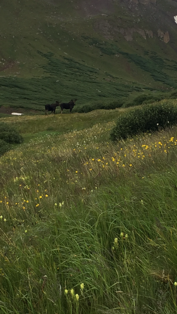
The alarm woke us up at 5am. It was dark and everything was soaking wet except for us in the tent. It was hard to want to crawl out of our sanctuary. But we knew there were even more storms forecast for today and we had more high elevation parts to ride before making it to Silverton. The entire section from where we camped to Stony Pass was above treeline. We packed our wet clothes began riding towards the next pass. The trail was soaked and slippery. Within a couple miles we ran into some large moose just ahead of us on the trail. They were majestic in the early morning light, but we kept our distance. They were skirting the trail and moving slowly. We stopped and watched them. Within ten minutes they were far enough from the trail that we felt comfortable moving along, even though whenever they heard us they turned around and glared at us disapprovingly.
After a brutal climb we found snow atop the pass and a herd of elk moving through. Even though it was early in the morning the clouds were building aggressively. We sat atop the pass eating the last of our snacks. I scooped trail butter out of the container and ate it with the last of my dried apricots. I loved the scenery and the beauty of our surroundings but I kept feeling overwhelmed by the stress of the weather and hating the feeling of having nowhere safe to retreat to.

After we dropped down from the pass we came to an intersection for Pole Creek, the route the CT used to follow before the new Cataract Ridge trail was built. According to the app this was considered an “optional” wilderness reroute. I was confused, not sure which way was the best to go. If we routed along Pole Creek we would descend and then have to re-climb our way to Stony Pass whereas if we stayed the course we would stay high but encounter a very remote and exposed portion of trail that may take several hours to ride/hike. Watching the clouds build and remembering the stress of the day before battling the possibility of storms and being stuck on exposed ridges we opted to take the Pole Creek route. I felt bad insisting but it seemed like the best call considering the conditions. Judging by the app, Pole Creek was an old jeep road, but once we got on it we realized it was more of a rutted and muddy moto trail. The descent took much longer than anticipated. I loved the parts we could ride but everything was so slick and slippery from the rain it was all pretty difficult. Our shoes were soaked through so we stopped gingerly trying to cross the creek and just splashed on through. It was still cold and overcast and the rain covers for my shoes were shot from walking the gravel road the night before.
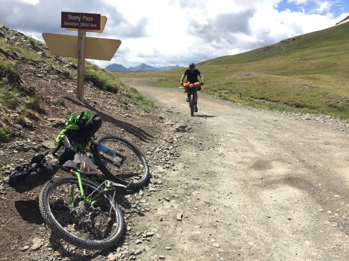
We finally got to the bottom of Pole Creek and met up with a forest road to begin our climb up to Stony Pass. The road got steep quickly and we gained 2,000 feet in 6 miles. But it was a rideable grade and my favorite kind of challenge, a sustained dirt road climb. After another rough morning and a lot of indecision I knew I was exactly where I wanted to be, cranking up a mountain on a dirt road. Harris wasn’t quite as in his element as I was since he was grappling with some knee pain. I left him to conquer his own climb. I loved looking back from the switchbacks and seeing him down below. The forest road was busy with ATVs and jeeps but we made swift work of the climb. Up at the top of Stony Pass I rode past a jeep tour. The guide gave me a high five and said I had more dedication than he did. “I’m just really hungry and I need to get to Silverton!” I told him, which was pretty much true. I passed an older couple that had driven past me on the climb up and the guy said to the woman, “that girl is still beating that boy!” I laughed when I told Harris and he said I should have told the guy I was usually beating him. We saw where the CT met the road at Stony Pass and knew we had made the right choice. The sky was black up above and chances are we would have only been somewhere in the middle of that section if we had opted to go that way.

I was feeling really good at the top of Stony Pass knowing that we had nothing but a ripping descent into Silverton where we had talked about getting a hotel room if the storms were still looking bad. I was ready for a little comfort after eight days without a shower. The descent off of Stony Pass was fast and chunky. I had very little braking power left but I still let myself go way too fast. We zigzagged our way around tight corners and eventually found our way to the main road leading to Silverton.
We were wet, muddy, and cold, but we could barely contain our excitement upon arriving in Silverton. The section from Buena Vista to Silverton is long and taxing. I hadn’t really realized what just passing through a town can do to boost morale when you’re hungry, thirsty, and tired. Silverton was bursting with tourists and we were overwhelmed by the activity. It was only noon but we knew we wanted to try to find a room, especially seeing rain and storms in every direction. It was time to take a break. Harris and I looked at each other and exclaimed “town day!” just like the thru-hikers we had seen a few days before. Everything was funny to us in the state we were in. We were giddy. We rode our bikes up and down the main drag trying to find a cheap hotel. Almost all of them had no vacancy signs up.
We thought we might be forced to just press on and camp again, but as we were heading up Main street in the other direction we saw the Prospector Motel. There was a vacancy sign! I knocked on the office door and a startled but jovial man opened the door to greet us. The rooms were cheap and could be ready within an hour. We were sold. There was an old Hardrock 100 poster on the office wall with Karl Meltzer’s signature. He told us Karl Meltzer had stayed there the first time he won the Hardrock. He told us the race had just wrapped up and most of the racers had just left town.
We rolled down to the Golden Block Brewery while he got our room ready. We each ordered a pizza and for the first time in a long while I ordered a beer. It felt so satisfying to be there and to have so much food at my beckon call. Of course I could only eat a few slices of pizza but I knew I’d finish it slowly over the next few hours.

I had lost my crocs on the wilderness detour so we went to a touristy outdoor store and got a cheap pair of flip flops. On our way back to the Prospector we saw a tall guy waving frantically at us from the other side of the road. It was Chase, Harris’ friend from Vermont that we had been chasing this whole time! He was having some complications with a broken spoke and had stayed in Silverton the night before at the hostel. He was considering staying again that night since he was still tracking down Silverton’s lone bike mechanic. We swapped stories of rowdy trails and wild weather and made plans to meet up later for some coffee or beers. Harris and I went back to the hotel and unpacked all our bags to dry everything out and reassess what we would need for the next couple days to get us home to Durango. We went grocery shopping and did laundry. I took a luxurious bath in the mint green tub and we checked in with friends and family who had been watching our erratic SPOT over the last couple days.
We met up with Chase for Mexican food and checked the weather together, trying to evaluate our options for the next few days. We were so close to home but still had some high sections of trail to get over, the scariest of which was Indian Trail Ridge, not the kind of place you’d want to get stuck during a lightning storm. The storms were supposed to start fairly early in the day with chances of storms beginning at 10am. We wanted to get as far as possible but knew it was realistic to count on getting home taking 2 more days. I thought we should get up at 3am and get riding by 4am. I got talked down to starting by 5am.
It was hard falling asleep in the huge king size bed knowing we’d be getting up at 4am, but eventually I fell asleep. Chase slept on his air mattress on the motel floor, squeaking every time he repositioned himself. Storms pounded the roof of the motel all night and every time I opened my eyes I saw lightning out the window.
Day 9.5 – Silverton to Ethan’s Birthday Party
Wednesday, July 20th, 2016
Miles: 39 (Weminuche Wilderness Detour, Segments 25-26)
The rain was just letting up when we awoke at 4am. I was so happy for my gear to be dry and packed. I drank my instant coffee and ate about 3 donuts. My adherence to my diet (which included avoiding sugar) was long gone. I just needed enough calories to finish this ride. We got ready to go quickly and hit the pavement of Silverton right at 5am. Harris shone his headlamp in front of me as I led up the front of the pack and Chase headed up the rear with his flashing red light. We had 6 miles to get up highway 550 to Molas Pass before rejoining singletrack. We doubted there would be much traffic at this time of day but if there was any we needed to be ready to move aside since there was zero shoulder on this section of mountain highway.
As we started climbing up 550 we were mesmerized by the fog hanging under the Needles mountain range. It looked so majestic and beautiful in the rising dawn. We only had to pull to the side of the highway a few times for semis but definitely made the right call to do the highway section early in the morning.

By the time we got to Molas Pass morning was breaking and the sky was pink all around us. “Pink sky at night, sailor’s delight. Pink sky at morning, sailors take warning,” Harris and Chase kept saying. The trail from Molas was phenomenal and though a little damp from the past few days of rain it was amazingly rideable. Riding in a pack of three, our spirits were high and we were enjoying riding with each other. Chase especially seemed stoked to have company after so many days alone in the wilderness. His exuberant personality and general enthusiasm were infectious even though there was definitely a collective fatigue in the group. Our attitudes buoyed us and we knew we would finish the CT, it was just a matter of time.

It was only 9:30am as we climbed up and over Rolling Mountain. As we were coming down the descent Harris flatted again. I gave him one of my tubes and his tire immediately went flat again. Even though he had checked his tire meticulously, he had missed a little thorn. I gave him my last good tube and he was able to get it to hold air. We caught up with Chase at Celebration Lake where he was filtering water. There were a couple thru-hikers and a day-hikers at Bolam Pass Road that we chatted with briefly. We asked them what they thought about the weather as we saw clouds building. They seemed unphased so I tried to adopt their attitude even though our goal was to get at least over Blackhawk Pass today.


We rode away from the group of hikers, thinking we wouldn’t see them again, but Harris flatted again right away. Chase and I swatted biting flies and tried to keep the morale up while Harris messed with his tire and was able to get it to seat tubeless again. Victory! We hoped it would be the end of our tire woes. As the clouds built overhead we started climbing our way to Blackhawk Pass. Luckily there seemed to be plenty of trees much of the way up. After we had been riding for about half an hour, Chase hollered for us to stop. He had a flat tire! Damn. We waited with Chase while he fixed his tire and it started raining lightly. We donned our rain gear and kept moving. We got a couple miles up the trail and then started hearing thunder and seeing lightning in the distance.
It was still so early, about noon, that we thought maybe we could just take a little break in the trees and let the storm pass. We snacked and sat under the trees in the rain, feeling safe even though we were seeing lightning all around. All the hikers we had interacted with previously in the day ended up passing us by on this section, seeming unperturbed by the conditions. Chase told us a story about backpacking in Maine with a group and getting caught in a lightning storm on Mount Katahdin. His group leader instructed everyone to get their sleeping pads out and put on all their rain gear and wait the storm out. They waited 12 hours. We hoped we wouldn’t be waiting that long, but the storm didn’t show any sign of passing.
A thru-hiker who had left his water filter at Celebration Lake and was coming back up Blackhawk Pass for the second time that day stopped to give us the scoop on what we could expect. He said the pass was fairly mellow and only exposed above treeline for about half a mile. He chatted with us for a while. For some reason he reminded me of all the punk kids I used to hang out with when I was younger. He had hilarious irreverent stories and seemed not to care about what people thought about him. He was much less neurotic and strange seeming than some of the other thru-hikers we had met. He was from Amarillo, Texas and was planning on finishing the CT in Durango and then turning around and hiking all the way back to Denver. I told him I loved the George Strait song “Amarillo by Morning.” He went on a rant about how it was a pretty good song and all but there was no county fair in Amarillo so George Strait was full of shit or maybe had never actually been to Amarillo. When we asked him how living in Amarillo was he told us it smelled like cow shit all the time but you just got used to.
It was pouring down rain now and I was tired of snacking and sitting in the cold. I was starting to shiver. We decided to pack our sleeping pads up and start moving towards the pass even if we were just walking. The heavy rain had made the trail slick and difficult to ride. We rode a bit, walked a bit. I was wearing my down jacket and hat, alternating between being freezing cold and burning up. We were covered in mud. Many of the thru-hikers who had passed us while we were taking cover had also retreated into the trees, many to make camp for the night. We got just below the pass as another storm system seemed to be moving in. We hung in some trees for a bit before deciding to take our chances and climb over the pass. It was hike-a-bike, but not too far. We thought we could be up and over from where we were in about 20 minutes.
We decided there was no time like the present and Chase led us up. Just as we crested the pass and could see the other side we saw lightning strike a switchback that we would be descending. We hopped on our bikes and rolled quickly down to treeline. We let out a collective sigh of relief and stopped to refill our water. It had been a wet, cold, and harrowing afternoon. It was already about 4pm and after making great time that morning our pace had slowed way down since we had been socked in by the storm. We decided we’d try to make it a little bit further before making camp for the night. We kept leapfrogging with thru-hikers as they were making a good pace and we were awkwardly slipping and sliding on the wet muddy trails. Somehow Chase knew all of them from staying at the hostel in Silverton. A couple girls had set up camp earlier in the storms and poked their heads out to say hello to us. When they saw Chase they got excited and said, “Hey, have you seen Boots and Taco?!” Chase said Boots and Taco had taken another rest day in Silverton. The girls groaned and called them lazy.
We got into a section of forest road and saw a sign with an arrow pointing the way we were headed that said “Ethan’s B-day Party” with a deflated balloon. Shortly afterward we found a nice campsite with plenty of room for both of our tents. I was freezing, wet, and muddy. We were all ready to try to find some dry clothes and settle in for the night. Luckily the rain had let up so we were able to cook dinner and set up camp without being rained on. We kept seeing a large deer grazing our camp site. We decided this was Ethan and we had crashed his party. A few thru-hikers passed us by and said they were going to camp several miles up. I was impressed by the dedication of the thru-hikers we leapfrogged on this section.
We climbed into our tents at dark. I felt lucky to have a dry place to lay and that my handlebar bag had kept my sleeping bag dry. There were more storms in the forecast for the next day but we really only had one high section to get over and then we would start our rollicking descent into Durango. It felt good to fall asleep knowing we just had about a half day of riding left. We were only 40 miles from home! Thinking back on the beginning of the trip felt like so long ago. I realized we had really lucked out on the weather at the beginning seeing now how different it can make the conditions. I kept thinking “well if the weather wasn’t so bad we would have been home by now” but I know conditions are part of the difficulty of the CT and probably the hardest thing for me to endure mentally when I’m already so beat down by the trail.
Day 10 – Ethan’s Birthday Party to Durango
Thursday, July 21st, 2016
Miles: 40 (Segments 27-28)
We were happy to see it wasn’t raining when we woke up to the alarm at 5:30am. We would be able to pack up our wet muddy gear without also getting rained on at the same time. I nudged Harris awake and he said “Huh, what do you want to do?” in a groggy voice. “Uh, it’s time to ride bikes!” I said and then he realized where he was. Chase was already up getting his tent broken down. I was excited but nervous like I always get on the final day of a trip. It’s never over until it’s over even though we were a day-ride away from home.


The riding started with some gentle climbing and very rideable though muddy trails. Eventually we started climbing more steeply towards Indian Trail Ridge and we could see the La Plata mountains in the distance. Our backyard! Indian Trail Ridge was unique — narrow and mostly made up of chunks of shale that clanked together ominously when you rode a bike over it. It was a beautiful morning and we got up and over the ridge pretty early. We ran into a large group of middle aged women from Durango who were out hiking for a few days together. They all looked so clean and smelled so good. They were impressed by our journey and so excited that they were seeing us on our final day. One of the women kept saying just how good we looked in spite of being out on the trail for days. We started seeing more and more day hikers and they were all excited to welcome us home.

When we dropped down to Taylor Lake I started to get cautiously optimistic about making it home in one piece. After Kennebec Pass it was mostly downhill to town. The descent off Kennebec was rowdy and sketchy. There was loose scree everywhere and I tried to keep myself in check since I really didn’t feel like I had much stopping power left. Even though I was out of water and needed to eat, I resisted stopping. I just didn’t feel like filtering any more water. In my head I was ready to be done and drinking a cold beverage at Carver’s. As we got lower in elevation the air started to feel positively swampy. I begged water off Harris, still stubbornly refusing to filter any more water.

Even though we tried to mentally prepare for it, the climb to the high point in the middle of this section was a kick in the teeth. I got grumpy and looking back I’m sure it was because I was dehydrated. I just tried to keep my head down and think about how far we had come and what we had been through already. Really this was small potatoes. I tried to keep my perspective.
I was skeptical we were at the high point once we got there so I checked the app. I was stoked to tell the guys it really was the high point. Morale was kind of low but we all perked up to realize just how close we were. I led the descent from here and couldn’t help but get into the speed of it, we were in tight formation ripping down the trail. We stopped once to regroup and Chase said he was stoked about the fast descending even though it felt slightly irresponsible to be riding that fast and furious at the end of such a long journey.
Finally we got to the Dry Fork trail intersection and in my heart we were already home. I had ridden this trail before. We were so close! When we got to Gudy’s Rest, a high point from town, we stopped to take a picture. There was a tourist out on a day ride and a couple hikers. They took pictures with our phones for us and then wanted to take a picture with their own phones to show their family they had met people who had actually done the entire Colorado Trail!
I was running on fumes and getting dehydrated but we were so close. I refused to stop. Finally we got to the Junction Creek TH and we all stopped to hug and high five. It had been such an intense few days and we had done it, together! It felt awesome. A thru-hiker sat under a tree and was psyched to tell us he had just finished up too. He took our picture in front of the sign and I offered to take his. He handed me a phone with a shattered screen and I tried to take a good shot even though I couldn’t see anything. He just told me to click a few times. He stuck out his tongue and flipped the camera the peace sign. We wished him well on getting a ride into town and jumped on our bikes for the 6 mile pavement cruise to town.

I desperately wanted a shower but I knew I needed food and drink more. We rolled up to Carver’s salivating at the sight. Just as we were putting our bikes on the rack we saw a local who was just about to head out on the Colorado Trail Race the next week. He was stoked to welcome us home and it felt so good to be back. We got drinks and way too much food and just sat and zoned out. My family started texting me seeing I was back in town. It felt good but surreal to be done. Another Durango friend saw our bikes outside and came in to congratulate us. We really were home! After we finished at Carver’s we crossed the street for ice cream and then rode the few blocks to home. Showering felt like a ceremony, I was sure to scrub every inch of my body. Harris’ parents really wanted to treat us to a celebratory dinner so they had called in a gift card to one of our favorite restaurants in Durango, Steamworks. We met up with Chase and his friend that had ridden the first part of the CT with him. When we picked up the gift card at the bar the bartender congratulated us on our ride, obviously Harris’ dad had talked us up when he called in the card. Instead of feeling embarrassed, I felt proud. It’s not everyday you finish the CT. The bartender told us he had bikepacked the trail several years ago. “That shit’s not easy,” he said with a grin and gave us some free beer cards.

Absolutely wonderful, we loved your story! Really something! Looking forward to meeting you soon. H
LikeLike
Great writing & congratulations!
-Stacy (friend of your dads & Leadville denizen)
LikeLike
Super rad! You guys really cooked through that trail. I’ll definitely have to go back to see the rest of it. Thinking about racing it? I hope to meet Harris someday– his mom is really great!
LikeLike
Although I read this in several installments and it took a while to finish this story, I was on the edge of my seat!! Such good writing and what an adventure. So proud of you two! Beautiful pictures too.
LikeLike
Awesome adventure and great writing and pictures! My girlfriend and I are going to start our southbound journey at the end of July 2017. Would you or Harris be willing to talk to me over the phone about your adventure in more depth to help us prepare? My email is john.hannan.williams@gmail.com or feel free to call or text at 443-632-4744! Thanks!
LikeLike